By Kendra Rounds
Snowstorms and blizzards can have immense impacts on human infrastructure, create hazardous travel conditions, and shut down cities due to snow and ice accumulation. Many people know this in general about snowstorms but have never considered if there’s any difference between snowstorms at different times of the year.
During midwinter – in, say, January – temperatures are colder overall with less sunlight during the daytime to diminish snow accumulation. Snowflakes that form around this time may be smaller and more powder-like. This can reduce visibility more quickly during snow events such as blizzards, which makes traveling conditions more hazardous. During early spring – in, say, April – temperatures are generally warmer with more sunlight throughout the day. While this typically means the effects of a snowstorm won’t last quite as long, the snow that falls is usually thicker and heavier, often called “wet snow.” This snow is much harder to clear from roadways and can cause power outages more easily due to the weight of the snow on powerlines. Many people probably wouldn’t consider that these storms can be so different if they don’t look at the underlying meteorological properties of these storms.
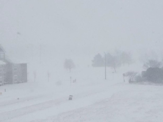
Two different storms that swept across the northern Great Plains in 2018 can be used as an example. These two storms, the first occurring on January 22nd and the second on April 14th, developed in a similar way but had slightly different impacts. Both storms were the result of a type of mid-latitude cyclone known as a “Colorado Low.” Colorado Lows are defined by the National Weather Service (NWS) Glossary as areas of low pressure that form over southeastern Colorado in the lee of the Rocky Mountains and move northeast over the central United States and that can bring blizzards and hazardous weather as they move along. Both storms were considered blizzards, meaning they had high winds and low visibility for the duration of the storms.
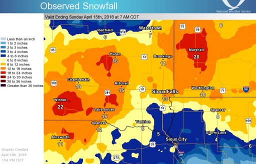
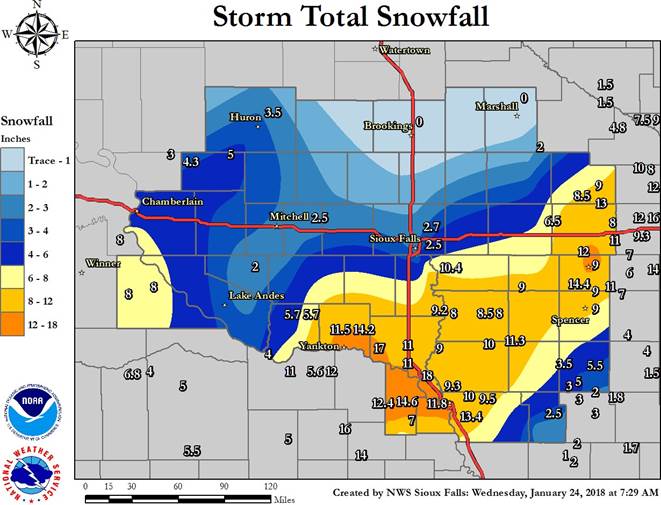
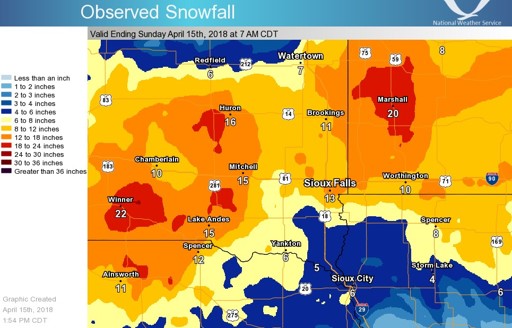
Focusing on the Sioux Falls region for consistency, the January storm produced winds from 35-50 mph with snowfall over a foot in some places. Sioux Falls itself got about 2-3 inches, and other regions got around 11 to 12 inches reaching up to 18 inches in one area. The April storm was considered a historic blizzard in Sioux Falls at the time as it broke some previous snowfall records. The winds over this storm gusted between 45- 65 mph with snowfall totals reaching well over a foot in many regions. Sioux Falls itself got about 13 inches while some other areas got as much as 22 inches (data courtesy of the NWS Sioux Falls Weather Forecasting Office). Both storms reduced visibility, made travel conditions extremely dangerous to impossible, and created massive snow drifts in their wake. The April blizzard also occurred during calving season, putting strain on farmers as they tried to protect the young cows. These storms developed similarly, which provides a good set up to determine what, if any, were the differences between the two storms on the microphysical level.
My senior capstone is a comparison analysis of these two blizzards in Sioux Falls, South Dakota. While I will be analyzing the overall large-scale weather systems that brought these storms to this area, I will be focusing my research on the difference between the precipitation microphysics of these storms using radar imagery. Precipitation microphysics refers to the physical properties that influence the formation and development of the precipitation (such as rain drops, snowflakes, or ice crystals) in the cloud and as they fall. You might be familiar with radar imagery if you have used a weather app to track thunderstorms. However, another aspect of radar technology is called dual polarization, which allows meteorologists to “see” much more information about the precipitation. As discussed in the National Severe Storms Laboratory (NSSL) “Winter 101” page, these radar images can determine more information about the size and shape of the target, which helps determine if the precipitation is rain, hail, snow, and ice pellets (or sleet) when combined with temperature data throughout the atmosphere. Previous studies have highlighted the benefit of using dual-polarization radar to help identify the unique microphysical properties of these storms and how they can relate to the overall storm development (Griffin et al. 2014).
Determining precipitation type is necessary because different precipitation types can have different impacts. For example, freezing rain can leave a layer of ice on the roads before being covered with snow, creating extremely hazardous driving conditions post-storm. Or heavy, wet snow can cause much higher snow accumulations, which can take longer to clear off roads. By examining the differences in precipitation microphysics, meteorologists can gain more insight into how these storms differ between the warm and cold seasons and can help improve winter weather forecasts for these times. An improved winter weather forecast can help people better prepare for these events, such as helping the city prepare adequate preparation plans for snow removal or allowing power companies to prepare for potential power outages.
References:
Griffin, E. M., T. J. Schuur, A. V. Ryzhkov, H. D. Reeves, and J. C. Picca, 2014: A Polarimetric and Microphysical Investigation of the Northeast Blizzard of 8–9 February 2013. Wea. Forecasting, 29, 1271–1294, https://doi.org/10.1175/WAF-D-14-00056.1.
Henson, H.H. (2018, April 14): Low visibility blizzard in Yankton, SD [Photograph]. NWS.
National Severe Storms Laboratory (n.d.): Severe Weather 101– Winter Weather: NOAA. Accessed 30 October 2026.
National Weather Service (n.d.): “Colorado Low” Glossary, weather.gov. Accessed 30 October 2026. https://forecast.weather.gov/glossary.php?word=colorado%20low.
Sioux Falls Weather Forecasting Office (2018): January 22, 2018 Blizzard. NWS. Accessed 30 October 2026. https://www.weather.gov/fsd/20180122-Blizzard-TriState.
Sioux Falls Weather Forecasting Office (2018): Storm Total Snowfall. [Graphic] NWS. Accessed 30 October 2026. https://www.weather.gov/fsd/20180122-Blizzard-TriState.
Sioux Falls Weather Forecasting Office (2018): Historic April Blizzard Impacts the Region. NWS. Accessed 30 October 2026. https://www.weather.gov/fsd/20180414-blizzard.
Sioux Falls Weather Forecasting Office (2018): Observed Snowfall. [Graphic] NWS. Accessed 30 October 2026. https://www.weather.gov/fsd/20180122-Blizzard-TriState.
Bio:
I am a senior Atmospheric and Environmental Sciences major with a Meteorology Specialization and a minor in Geospatial Technologies. I have always enjoyed the weather ever since I was a little kid watching The Weather Channel on TV or watching thunderstorms roll in with my dad. Although I officially hadn’t decided for certain what I wanted to pursue until late into my high school career, deep down I knew it could only be meteorology as I kept coming back to it whenever I considered career paths. As I began to learn more about the science of meteorology, I developed a particular interest in precipitation formation, especially in winter weather, among other things. I hope to continue my love of meteorology by one day working as an operational meteorologist, forecasting and communicating important information to the public, hopefully with the National Weather Service. Outside of meteorology, I enjoy exploring the Black Hills, swimming, reading, and doing crafts.

