By Ryenne “Rye” Julian
Did you know that sea ice, especially in the Arctic, is forecasted just like the weather? It turns out that sea ice is both a significant tool and obstacle for people residing in areas of the Arctic circle, subsistence hunters, ships looking to navigate through the Arctic passages, and people studying the climatology of the Arctic tundra. So, yes – it’s a little bit important to understand how ice is changing, moving, and behaving daily. Although a lot of work is done to collect data about ice through physical measurements and buoy tracking, satellites play a major role in monitoring the conditions of ice. The only drawback with satellites is that many of them are unable to take readings at night and though clouds (for example, the NOAA – 20 Visual Infrared Imaging Radiometer Suite (VIIRS)), which proves an issue on many days, especially during the Arctic winter when the North Pole is cast in 24-hour darkness.
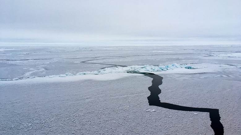
How can we go about navigating this issue? Although most of the Arctic circle freezes up during winter, thus limiting shipping operations, being able to make ice forecasts is still vital to residents of the area, local tribal nations, climate records, and subsistence hunters. The specific variable of interest for this project is sea ice concentration, which is defined as the understanding of the percentile of ice present. For example, an 80% ice concentration means that there is an 80% chance that ice is present in that area – it has nothing to do with ice depth, thickness, or extent. Understanding sea ice concentrations is especially important during the spring and summer seasons, when monitoring areas where the ice edge meets ocean water becomes both difficult and an active threat to human safety. But… if satellites can’t tell us this information all year long, and buoys may not be a feasible option for continuous monitoring, what can we do?
This summer, I had the privilege of studying with ice scientists at the National Atmospheric Ocean Administration (NOAA) as a recipient of the Ernest F. Hollings student scholarship and internship program. I have family members who have worked in Alaska, Greenland, and Antarctica, which sparked my interest in studying polar meteorology and climatology. So, when I got to choose what research to do, it made the most sense for me to work on something that dealt with monitoring ice changes. I quickly became indoctrinated into the world of ice forecasting as a novice researcher with one primary goal: find a way to consistently monitor sea ice concentration for ice forecasting.
Our primary satellite products that we have been using as tools for our research are the Synthetic Aperture Radar (SAR), the NOAA – 20 Visual Infrared Imaging Radiometer Suite (VIIRS) sea ice concentration product, and an AI product by the title of IceLynx. IceLynx is trained purely off the data received by SAR, and SAR is essentially just a radar in space that shoots down lasers and creates an image based on the roughness of the surface the laser just hit. The upside to SAR is that it is not inhabited by lack of light or clouds, making it the perfect instrument for continuous sea ice concentration.
You may be thinking, Wow! If SAR can do all of that, why do we even need to do this research? Unfortunately, SAR sometimes gets things wrong. Sometimes, it can mistake rough winds on the surface of the ocean like ice. Or it can make mistakes with puddles that form on the top of ice as they melt as areas of open water. This problematic phenomenon is known as “tone reversal,” which makes SAR backscatter values rather difficult to interpret. For example, what if ice forecasters were to tell a shipping vessel there was a big patch of open water, when there is a thick sheet of ice with a few inches of melting water on top? Dangerous consequences may ensue. Since the IceLynx AI product is trained only off SAR, it is prone to inaccurate readings as well, wasting the time and energy of the ice forecasters.

So, the primary goal of our research is the following: if we can derive a relationship between the SAR backscatter values and true sea ice concentrations from the VIIRS data, then we may be better able to navigate the issue of tone reversal and help retrain various AI products as well as inform ice forecasters what to look out for when tone reversal is occurring. If we can complete our goal utilizing ArcGIS Pro to parse through our satellite data and start examining statistical relationships that occur between certain backscatter values and sea ice concentrations, then we may be able to help the ice forecasters around the globe stop asking themselves: “Where the heck is the ice?”
Ryenne “Rye” C. Julian is a senior Atmospheric and Environmental Sciences (AES) undergraduate student set to graduate in December of 2026. They have had a variety of internship opportunities working with topics such as small-scale climate research, helping to write a climate action plan, studying micrometeorology and agrivoltaics, and most recently, studying how applied remote sensing methods can be used to study sea ice and better train ice forecasting AI programs with the National Oceanic and Atmospheric Administration (NOAA). Her passion for the study of ice came from the start of her undergraduate degree being spent at Northland College as a climatology student before transferring to South Dakota Mines in 2024 because of Northland College’s closure. At SD Mines they have been able to apply both meteorological and climatological methods to their studies.